This map shows temperature departures from average. Areas in bright red indicate temperatures of up to 36° hotter than normal. Siberia in pink is abt. 35 degrees below normal.
rawstory.com, DAVID FERGUSON, 11-18-2016
36 degrees above normal
Scientists studying Arctic weather patterns say that the region at the top of the world is freakishly hot for this time of year – a whopping 36 degrees F (20 degrees C) above normal. . . .
Meanwhile, a massive bubble of cold air is hovering over central Asia, bringing record cold temperatures to Siberia.
Scientists say that a number of factors contribute to the unusually warm polar temperatures. The jet stream is pushing warm, moist air in from the south and showing greater variations from its usual path for longer amounts of time.
Climatologist Jennifer Francis told the program NOVA that “we’re moving toward an increased tendency for the jet stream to get into these big wavy patterns that tend to move more slowly . . . So the weather that’s associated with them on the surface — either the storms or the high pressure areas, whatever it is — are going to stick around longer at a given location.”
This leads to an increased number of severe weather incidents that last for longer periods of time. It also causes more warm, moist air to move into the northernmost parts of the northern hemisphere, which melts Arctic ice, slowing the Jet Stream down even more.
. . . “The extreme behavior of the Arctic in 2016 seems to be in no hurry to quit,” Francis told the Washington Post.
Climatologist Richard James said on his blog, “It is amazing to see that the warmth has become even more pronounced since the end of October.”
Mark Serreze, head of the National Snow and Ice Data Center in Boulder told the Post that what’s happening is a “double whammy.”
Lack of sea ice has led to a “very warm underlying ocean,” he said. Jet Stream anomalies then pump warmer air into the Arctic and drive colder air into Siberia.
“The sea ice is at a record low right now, for this time of year, that’s one thing,” Serreze said. “And why it’s so low — again, there’s so much heat in the upper ocean in these ice-free areas, the ice just can’t form right now. The ocean’s just got to get rid of this heat somehow, and it’s having a hard time doing so.”
Amid higher global temperatures, sea ice at record lows at poles
CNN – By Brandon Miller, CNN Meteorologist, November 18, 2016
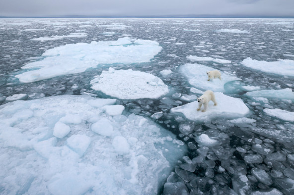
For what appears to be the first time since scientists began keeping track, sea ice in the Arctic and the Antarctic are at record lows this time of year.
While record low sea ice is nothing new in the Arctic, this is a surprising turn of events for the Antarctic.
. . . sea ice in the northern latitudes is at a lower level than ever observed for this time of the year. October and November are typically a time of rapid ice gain for the Arctic region, as daylight hours become shorter and shorter and eventually non-existent during what’s referred to as the “polar night.” Air temperatures plummet to below zero degrees Fahrenheit and parts of the Arctic Ocean not covered with ice quickly become covered. But this year, those air temperatures are staying much warmer, closer to the freezing mark of 32 degrees Fahrenheit. . . .
“The interaction between Arctic ocean temperatures and the loss of ice formation leading to continuing record minimums is clearly a climate change signal,” said Thomas Mote, a geography research professor at the University of Georgia.
As it becomes clearer that the entire climate system in the Arctic, and potentially the Antarctic, is changing rapidly, the question now is what the impacts will be. . . . The Arctic region impacts the weather in the rest of the planet — in particular, North America, Europe and Asia.
Even though that Arctic air might not be as cold as normal, it is still plenty frigid to wreak havoc on populated places, locking them into long cold spells and major snow storms.
There’s a classic example of it happening right now. Large swaths of Europe and Asia have seen bitter cold and record snows over the past several weeks, all while the Arctic was bathing in temperatures 30 degrees Fahrenheit above average.
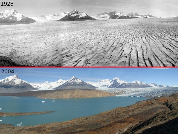
Upsala Glacier 1928-2004


Last Year
Storm Pushes North Pole 50 Degrees Above Normal
By Angela Fritz, The Washington Post, 12-31-2015
A powerful winter cyclone — the same storm that led to two tornado outbreaks in the United States and disastrous river flooding — has driven the North Pole to the freezing point this week, 50 degrees above average for this time of year….
NOAA’s Ocean Prediction Center said the storm’s minimum pressure dropped to 928 millibars around 1 a.m. Eastern time, which likely places it in the top five strongest storms on record in this region.
On Wednesday morning, temperatures over a vast area around North Pole were somewhere between 30 and 35 degrees Fahrenheit, . . . “Consider the average winter temperature there is around 20 degrees below zero,” wrote the Capital Weather Gang’s Jason Samenow on Monday. A temperature around the freezing mark signifies a departure from normal of over 50 degrees, and close to typical mid-summer temperatures in this region.
In other words, the area around the North Pole was … warmer than much of the Midwest.
Full article at
readersupportednews.org/news-section2/318-66/34349-storm-pushes-north-pole-50-degrees-above-normal-for-this-time-of-year


